Forecasters are calling for more snow this week on Long Island.
After parts of the island saw as high as 8 inches on Tuesday, meteorologists at the National Weather Service have put a Winter Weather Advisory in place on Saturday, Feb. 17, from midnight to 10 a.m.
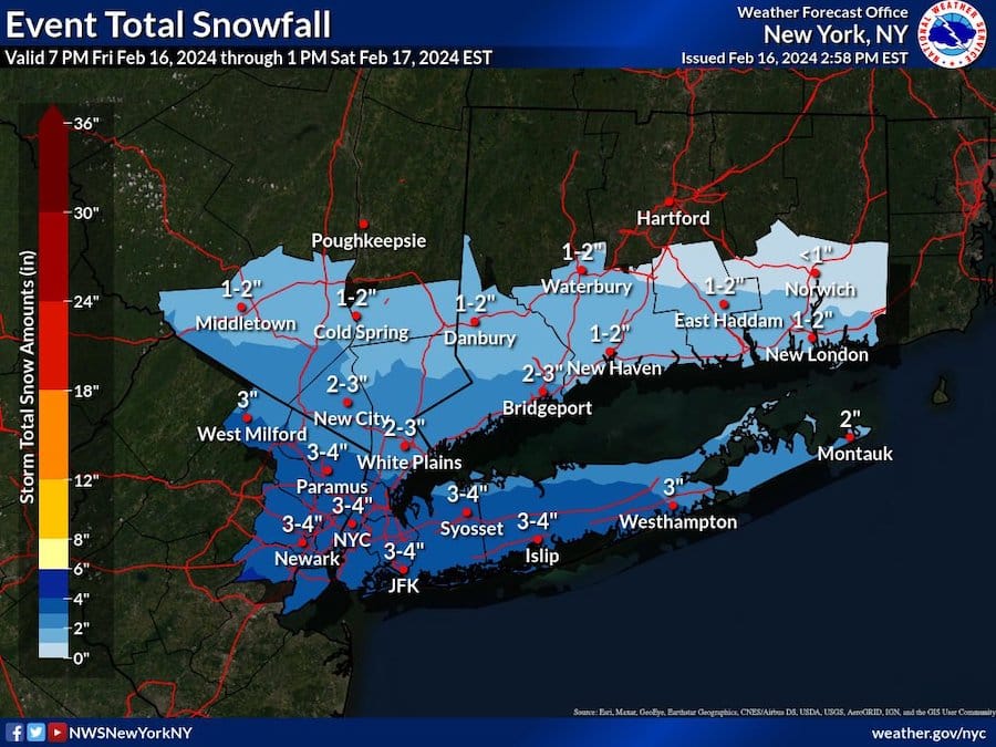
From Friday night into Saturday, the NWS expects 2-4 inches of snow across Long Island, with most of the accumulation in Nassau and western Suffolk. See the map below.
“Plan on slippery road conditions,” reads part of the advisory.
Here’s the current forecast for central Long Island, as per the NWS:
Friday night
A slight chance of snow showers between 10pm and 1am, then snow after 1am. Low around 26. Northwest wind 5 to 13 mph becoming northeast after midnight. Chance of precipitation is 90%. Total nighttime snow accumulation of 1 to 3 inches possible.
Saturday morning
Snow, mainly before 10am, then a chance of snow showers after noon. High near 37. Wind chill values between 25 and 30. Northeast wind 5 to 13 mph becoming northwest in the afternoon. Chance of precipitation is 80%. New snow accumulation of 1 to 2 inches possible.
Saturday night
Partly cloudy, with a low around 21. Wind chill values between 10 and 15. Northwest wind 9 to 14 mph.
Top: File photo of a frozen traffic light in Stony Brook, New York. (Photo by Andrew Theodorakis/GLI Photo via Getty Images)
Your Long Island news, delivered.
Subscribe to the GLI Newsletter — its free